
- Start >
- Groundwater >
- Waterlevel of upper layer >
- Untere Donau >
- Mertseebecken 1 >
- Chart of total period

Chart of total period Mertseebecken 1
Groundwater levels of the total period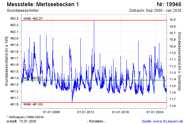
note
GW Messstelle im SN HRB Mertsee EG
Groundwater level [m above sealevel]: 401.60
Distance to surface [m]: 11.18
Last value from 06.01.2026 00:00
Ground level [m above sealevel]: 412.78
| Date | Groundwater level [m above sealevel] |
|---|---|
| 05.01.2026 | 401.20 |
| 04.01.2026 | 401.20 |
| 03.01.2026 | 401.20 |
| 02.01.2026 | 401.20 |
| 01.01.2026 | 401.19 |
| 31.12.2025 | 401.19 |
| 30.12.2025 | 401.19 |
| 29.12.2025 | 401.19 |
© Bayerisches Landesamt für Umwelt 2026