
- Start >
- Groundwater >
- Waterlevel of upper layer >
- Untere Donau >
- HWS SN Passau Donaulände BK08 >
- Chart of total period

Chart of total period HWS SN Passau Donaulände BK08
Groundwater levels of the total period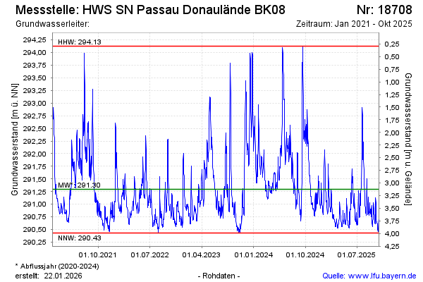
Groundwater level [m above sealevel]: 290.42
Distance to surface [m]: 4.00
Last value from 05.02.2026 07:10
Ground level [m above sealevel]: 294.42
| Date | Groundwater level [m above sealevel] |
|---|---|
| 05.02.2026 | 290.38 |
| 04.02.2026 | 290.38 |
| 03.02.2026 | 290.40 |
| 02.02.2026 | 290.36 |
| 01.02.2026 | 290.41 |
| 31.01.2026 | 290.44 |
| 30.01.2026 | 290.47 |
| 29.01.2026 | 290.48 |
© Bayerisches Landesamt für Umwelt 2026