
- Start >
- Groundwater >
- Waterlevel of upper layer >
- Obere Donau >
- THIERHAUPTEN I D 85 >
- Chart of total period

Chart of total period THIERHAUPTEN I D 85
Groundwater levels of the total period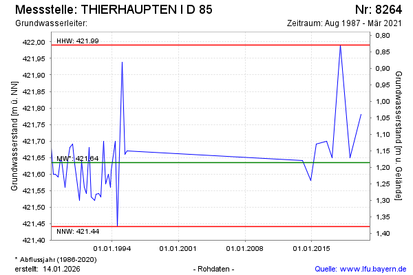
Groundwater level [m above sealevel]: 421.67
Distance to surface [m]: 1.15
Last value from 03.03.2021 13:00
Ground level [m above sealevel]: 422.82
| Date | Groundwater level [m above sealevel] |
|---|---|
| 03.03.2020 | 421.78 |
| 24.01.2019 | 421.65 |
| 18.01.2018 | 421.99 |
| 16.02.2017 | 421.65 |
| 03.08.2016 | 421.70 |
| 06.07.2015 | 421.69 |
| 28.11.2014 | 421.58 |
| 28.01.2014 | 421.64 |
© Bayerisches Landesamt für Umwelt 2026