
- Start >
- Groundwater >
- Waterlevel of upper layer >
- Obere Donau >
- ROTHSCHWAIGE Q 12 >
- Current data

Current data ROTHSCHWAIGE Q 12
Groundwater levels of the last 12 months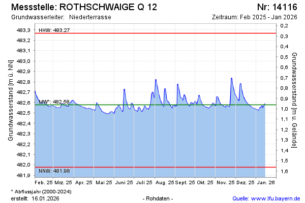
Groundwater level [m above sealevel]: 482.59
Distance to surface [m]: 0.95
Last value from 21.05.2026 10:00
Ground level [m above sealevel]: 483.54
| Date | Groundwater level [m above sealevel] |
|---|---|
| 21.05.2026 | 482.59 |
| 20.05.2026 | 482.57 |
| 19.05.2026 | 482.57 |
| 18.05.2026 | 482.54 |
| 17.05.2026 | 482.54 |
| 16.05.2026 | 482.55 |
| 15.05.2026 | 482.54 |
| 14.05.2026 | 482.54 |
© Bayerisches Landesamt für Umwelt 2026