
- Start >
- Groundwater >
- Waterlevel of upper layer >
- Obere Donau >
- OBERHAIDMUEHLE 119 >
- Chart of total period

Chart of total period OBERHAIDMUEHLE 119
Groundwater levels of the total period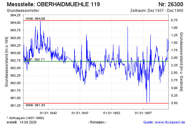
note
Messung seit 1960 eingestellt.
Groundwater level [m above sealevel]: 383.11
Distance to surface [m]: 1.73
Last value from 27.12.1960 12:00
Ground level [m above sealevel]: 384.84
| Date | Groundwater level [m above sealevel] |
|---|---|
| 19.12.1960 | 383.13 |
| 12.12.1960 | 383.31 |
| 05.12.1960 | 383.43 |
| 28.11.1960 | 383.12 |
| 21.11.1960 | 383.09 |
| 14.11.1960 | 383.08 |
| 07.11.1960 | 383.10 |
| 31.10.1960 | 383.08 |
© Bayerisches Landesamt für Umwelt 2026