
- Start >
- Groundwater >
- Waterlevel of upper layer >
- Obere Donau >
- NORDHEIM WESTL.EB. 3 >
- Chart of total period

Chart of total period NORDHEIM WESTL.EB. 3
Groundwater levels of the total period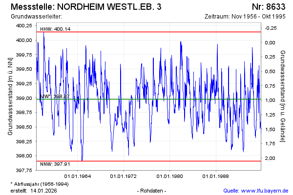
Groundwater level [m above sealevel]: 398.36
Distance to surface [m]: 1.60
Last value from 30.10.1995 12:00
Ground level [m above sealevel]: 399.96
| Date | Groundwater level [m above sealevel] |
|---|---|
| 23.10.1995 | 398.39 |
| 17.10.1995 | 398.41 |
| 09.10.1995 | 398.44 |
| 02.10.1995 | 398.47 |
| 25.09.1995 | 398.51 |
| 19.09.1995 | 398.52 |
| 11.09.1995 | 398.56 |
| 04.09.1995 | 398.58 |
© Bayerisches Landesamt für Umwelt 2026