
- Start >
- Groundwater >
- Waterlevel of upper layer >
- Obere Donau >
- Neu-Ulm, Ludwigsfeld, Ulmer Ried >
- Chart of total period

Chart of total period Neu-Ulm, Ludwigsfeld, Ulmer Ried
Groundwater levels of the total period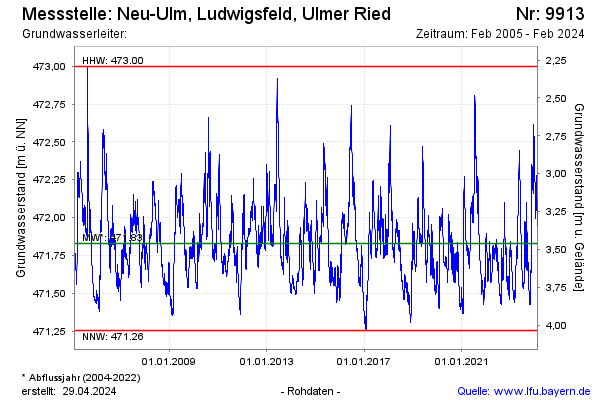
Groundwater level [m above sealevel]: 471.94
Distance to surface [m]: 3.35
Last value from 08.04.2024 12:30
Ground level [m above sealevel]: 475.29
| Date | Groundwater level [m above sealevel] |
|---|---|
| 31.03.2024 | 471.95 |
| 30.03.2024 | 471.96 |
| 29.03.2024 | 471.97 |
| 28.03.2024 | 471.97 |
| 27.03.2024 | 471.97 |
| 26.03.2024 | 471.97 |
| 25.03.2024 | 471.97 |
| 24.03.2024 | 471.96 |
© Bayerisches Landesamt für Umwelt 2024