
- Start >
- Groundwater >
- Waterlevel of upper layer >
- Obere Donau >
- Neu-Ulm, Ludwigsfeld, Ortsrand SW >
- Chart of total period

Chart of total period Neu-Ulm, Ludwigsfeld, Ortsrand SW
Groundwater levels of the total period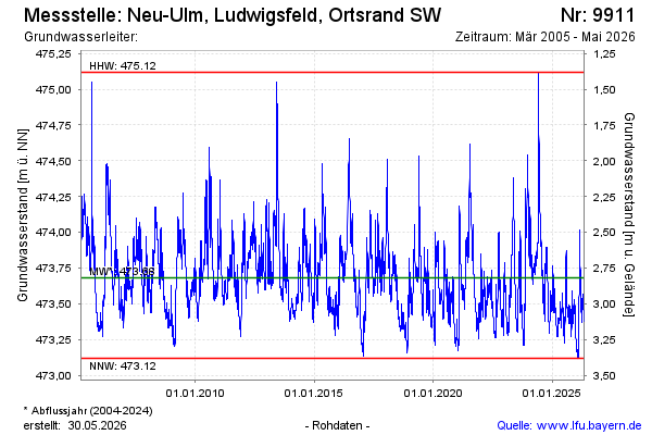
Groundwater level [m above sealevel]: 473.58
Distance to surface [m]: 2.92
Last value from 06.11.2025 09:53
Ground level [m above sealevel]: 476.50
| Date | Groundwater level [m above sealevel] |
|---|---|
| 06.11.2025 | 473.58 |
| 05.11.2025 | 473.59 |
| 04.11.2025 | 473.59 |
| 03.11.2025 | 473.56 |
| 02.11.2025 | 473.56 |
| 01.11.2025 | 473.56 |
| 31.10.2025 | 473.56 |
| 30.10.2025 | 473.55 |
© Bayerisches Landesamt für Umwelt 2025