
- Start >
- Groundwater >
- Waterlevel of upper layer >
- Obere Donau >
- Feuchtwangen-Krapfenau >
- Chart of total period

Chart of total period Feuchtwangen-Krapfenau
Groundwater levels of the total period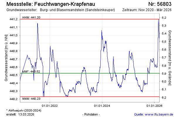
Groundwater level [m above sealevel]: 440.67
Distance to surface [m]: 5.75
Last value from 08.12.2025 13:00
Ground level [m above sealevel]: 446.42
| Date | Groundwater level [m above sealevel] |
|---|---|
| 08.12.2025 | 440.67 |
| 07.12.2025 | 440.66 |
| 06.12.2025 | 440.66 |
| 05.12.2025 | 440.66 |
| 04.12.2025 | 440.67 |
| 03.12.2025 | 440.67 |
| 02.12.2025 | 440.67 |
| 01.12.2025 | 440.66 |
© Bayerisches Landesamt für Umwelt 2025