
- Start >
- Groundwater >
- Waterlevel of upper layer >
- Obere Donau >
- BRUNN-PREZENGRAB 143 >
- Chart of total period

Chart of total period BRUNN-PREZENGRAB 143
Groundwater levels of the total period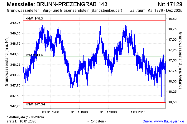
Groundwater level [m above sealevel]: 348.18
Distance to surface [m]: 17.67
Last value from 19.03.2026 09:15
Ground level [m above sealevel]: 365.85
| Date | Groundwater level [m above sealevel] |
|---|---|
| 19.03.2026 | 348.18 |
| 18.03.2026 | 348.17 |
| 17.03.2026 | 348.19 |
| 16.03.2026 | 348.24 |
| 15.03.2026 | 348.28 |
| 14.03.2026 | 348.38 |
| 13.03.2026 | 348.29 |
| 12.03.2026 | 348.21 |
© Bayerisches Landesamt für Umwelt 2026