
- Start >
- Groundwater >
- Waterlevel of upper layer >
- Obere Donau >
- BELLENB./MUEHLB. 1604 >
- Chart of total period

Chart of total period BELLENB./MUEHLB. 1604
Groundwater levels of the total period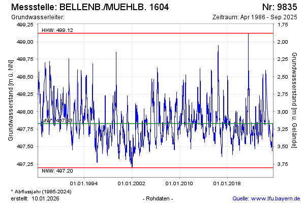
Groundwater level [m above sealevel]: 497.82
Distance to surface [m]: 3.18
Last value from 17.03.2026 13:18
Ground level [m above sealevel]: 501.00
| Date | Groundwater level [m above sealevel] |
|---|---|
| 17.03.2026 | 497.82 |
| 16.03.2026 | 497.83 |
| 15.03.2026 | 497.83 |
| 14.03.2026 | 497.84 |
| 13.03.2026 | 497.85 |
| 12.03.2026 | 497.86 |
| 11.03.2026 | 497.87 |
| 10.03.2026 | 497.88 |
© Bayerisches Landesamt für Umwelt 2026