
- Start >
- Groundwater >
- Waterlevel of upper layer >
- Isar >
- ORTHOFEN R 23 >
- Chart of total period

Chart of total period ORTHOFEN R 23
Groundwater levels of the total period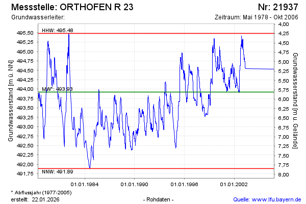
note
Die Messstelle wurde 2008 zurück gebaut.
Groundwater level [m above sealevel]: 494.25
Distance to surface [m]: 5.48
Last value from 25.10.2006 09:05
Ground level [m above sealevel]: 499.73
| Date | Groundwater level [m above sealevel] |
|---|---|
| 20.09.2006 | 494.53 |
| 02.05.2003 | 494.55 |
| 01.05.2003 | 494.55 |
| 30.04.2003 | 494.55 |
| 29.04.2003 | 494.56 |
| 28.04.2003 | 494.57 |
| 27.04.2003 | 494.57 |
| 26.04.2003 | 494.58 |
© Bayerisches Landesamt für Umwelt 2026