
- Start >
- Groundwater >
- Waterlevel of upper layer >
- Isar >
- MITTERWÖHR KL.ISAR 70/59 >
- Current data

Current data MITTERWÖHR KL.ISAR 70/59
Groundwater levels of the last 12 months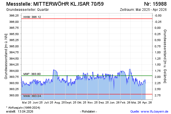
Groundwater level [m above sealevel]: 383.49
Distance to surface [m]: 2.26
Last value from 05.05.2026 10:00
Ground level [m above sealevel]: 385.75
| Date | Groundwater level [m above sealevel] |
|---|---|
| 05.05.2026 | 383.46 |
| 04.05.2026 | 383.50 |
| 03.05.2026 | 383.48 |
| 02.05.2026 | 383.52 |
| 01.05.2026 | 383.39 |
| 30.04.2026 | 383.41 |
| 29.04.2026 | 383.43 |
| 28.04.2026 | 383.43 |
© Bayerisches Landesamt für Umwelt 2026