
- Start >
- Groundwater >
- Waterlevel of upper layer >
- Isar >
- LOHHOF 275A >
- Chart of total period

Chart of total period LOHHOF 275A
Groundwater levels of the total period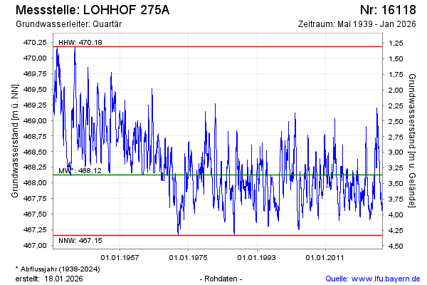
note
Die Messstelle wird aufgrund geringer Grundwasserergiebigkeit in den nächsten Wochen aufgelassen. Wir bitten um Ihr Verständnis.
Groundwater level [m above sealevel]: 467.85
Distance to surface [m]: 3.64
Last value from 09.03.2026 09:00
Ground level [m above sealevel]: 471.49
| Date | Groundwater level [m above sealevel] |
|---|---|
| 09.03.2026 | 467.86 |
| 08.03.2026 | 467.86 |
| 07.03.2026 | 467.87 |
| 06.03.2026 | 467.87 |
| 05.03.2026 | 467.88 |
| 04.03.2026 | 467.88 |
| 03.03.2026 | 467.89 |
| 02.03.2026 | 467.89 |
© Bayerisches Landesamt für Umwelt 2026