
- Start >
- Groundwater >
- Waterlevel of upper layer >
- Isar >
- Hohenlinden 2 >
- Chart of total period

Chart of total period Hohenlinden 2
Groundwater levels of the total period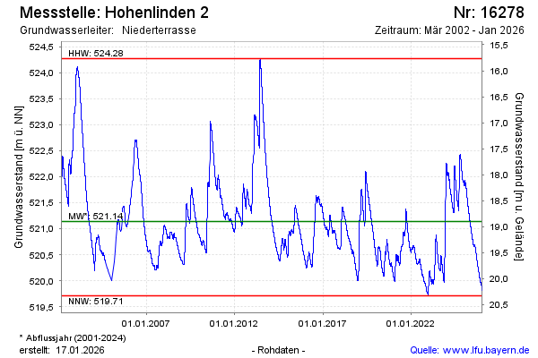
note
Aktuell Datenfernübertragung defekt. Wir arbeiten daran.
Groundwater level [m above sealevel]: 521.21
Distance to surface [m]: 18.82
Last value from 01.05.2024 10:00
Ground level [m above sealevel]: 540.03
| Date | Groundwater level [m above sealevel] |
|---|---|
| 01.05.2024 | 521.21 |
| 30.04.2024 | 521.21 |
| 29.04.2024 | 521.21 |
| 28.04.2024 | 521.22 |
| 27.04.2024 | 521.23 |
| 26.04.2024 | 521.23 |
| 25.04.2024 | 521.24 |
| 16.04.2024 | 521.31 |
© Bayerisches Landesamt für Umwelt 2024