
- Start >
- Groundwater >
- Waterlevel of upper layer >
- Isar >
- GABLINGEN 880 >
- Chart of total period

Chart of total period GABLINGEN 880
Groundwater levels of the total period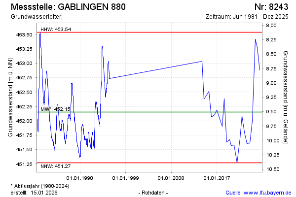
Groundwater level [m above sealevel]: 452.15
Distance to surface [m]: 9.51
Last value from 16.12.2025 10:00
Ground level [m above sealevel]: 461.66
| Date | Groundwater level [m above sealevel] |
|---|---|
| 04.06.2025 | 452.88 |
| 03.06.2025 | 452.88 |
| 05.12.2024 | 453.27 |
| 05.07.2024 | 453.42 |
| 15.12.2023 | 452.00 |
| 15.06.2023 | 451.61 |
| 30.11.2022 | 451.60 |
| 20.06.2022 | 451.80 |
© Bayerisches Landesamt für Umwelt 2026