
- Start >
- Groundwater >
- Waterlevel of upper layer >
- Isar >
- DB-FAHRLEITUNGSBAU 36 >
- Current data

Current data DB-FAHRLEITUNGSBAU 36
Groundwater levels of the last 12 months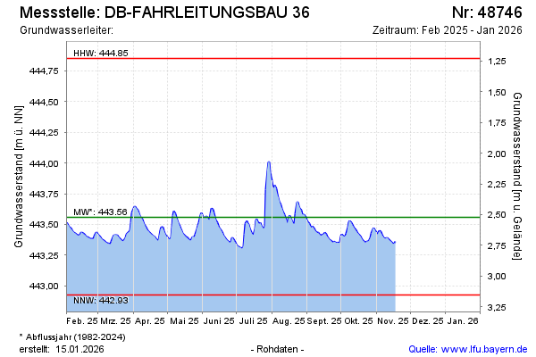
Groundwater level [m above sealevel]: 443.35
Distance to surface [m]: 2.73
Last value from 05.05.2026 09:56
Ground level [m above sealevel]: 446.08
| Date | Groundwater level [m above sealevel] |
|---|---|
| 05.05.2026 | 443.53 |
| 04.05.2026 | 443.54 |
| 03.05.2026 | 443.54 |
| 02.05.2026 | 443.54 |
| 01.05.2026 | 443.54 |
| 30.04.2026 | 443.54 |
| 29.04.2026 | 443.54 |
| 28.04.2026 | 443.54 |
© Bayerisches Landesamt für Umwelt 2026