
- Start >
- Groundwater >
- Waterlevel of upper layer >
- Isar >
- AISINGER LANDSTR. 30 >
- Chart of total period

Chart of total period AISINGER LANDSTR. 30
Groundwater levels of the total period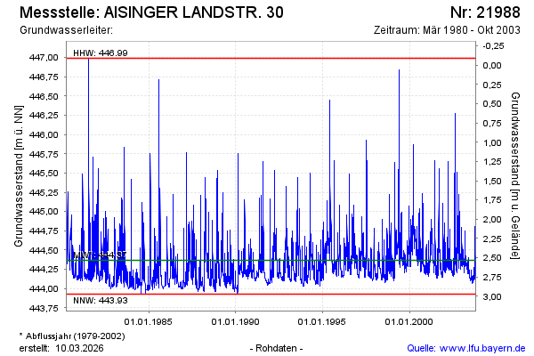
note
Die Messstelle wird nicht mehr beobachtet
Groundwater level [m above sealevel]: 444.17
Distance to surface [m]: 2.73
Last value from 01.11.2003 00:00
Ground level [m above sealevel]: 446.90
| Date | Groundwater level [m above sealevel] |
|---|---|
| 31.10.2003 | 444.17 |
| 30.10.2003 | 444.18 |
| 29.10.2003 | 444.18 |
| 28.10.2003 | 444.18 |
| 27.10.2003 | 444.19 |
| 26.10.2003 | 444.20 |
| 25.10.2003 | 444.22 |
| 24.10.2003 | 444.21 |
© Bayerisches Landesamt für Umwelt 2026