
- Start >
- Groundwater >
- Waterlevel of upper layer >
- Inn >
- WEIHENLINDEN R 11A >
- Chart of total period

Chart of total period WEIHENLINDEN R 11A
Groundwater levels of the total period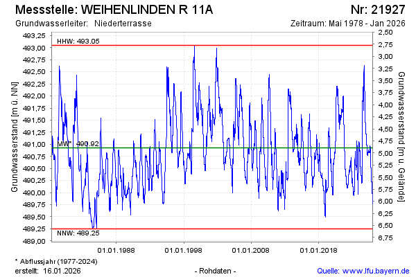
note
Die Messstelle musste 2011 verlegt werden !
Groundwater level [m above sealevel]: 490.42
Distance to surface [m]: 5.40
Last value from 20.05.2026 09:00
Ground level [m above sealevel]: 495.82
| Date | Groundwater level [m above sealevel] |
|---|---|
| 20.05.2026 | 490.42 |
| 19.05.2026 | 490.42 |
| 18.05.2026 | 490.42 |
| 17.05.2026 | 490.42 |
| 16.05.2026 | 490.42 |
| 15.05.2026 | 490.42 |
| 14.05.2026 | 490.42 |
| 13.05.2026 | 490.41 |
© Bayerisches Landesamt für Umwelt 2026