
- Start >
- Groundwater >
- Waterlevel of upper layer >
- Inn >
- Hammersbach T3-F >
- Chart of total period

Chart of total period Hammersbach T3-F
Groundwater levels of the total period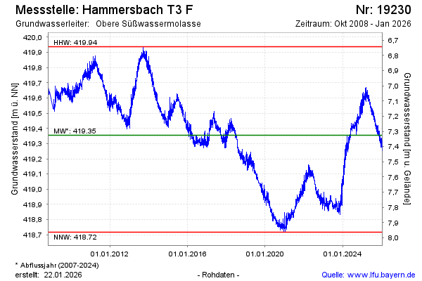
note
GW Messstelle im Grundnetz
Groundwater level [m above sealevel]: 419.13
Distance to surface [m]: 7.55
Last value from 20.05.2026 08:00
Ground level [m above sealevel]: 426.68
| Date | Groundwater level [m above sealevel] |
|---|---|
| 20.05.2026 | 419.14 |
| 19.05.2026 | 419.14 |
| 18.05.2026 | 419.15 |
| 17.05.2026 | 419.15 |
| 16.05.2026 | 419.17 |
| 15.05.2026 | 419.19 |
| 14.05.2026 | 419.20 |
| 13.05.2026 | 419.18 |
© Bayerisches Landesamt für Umwelt 2026