
- Start >
- Groundwater >
- Waterlevel of upper layer >
- Inn >
- GWM4-HWS Freilassing >
- Chart of total period

Chart of total period GWM4-HWS Freilassing
Groundwater levels of the total period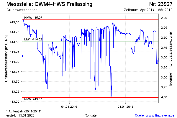
note
Messstelle aufgelassen (07.03.2019) und verfüllt.
Groundwater level [m above sealevel]: 413.91
Distance to surface [m]: 3.20
Last value from 07.03.2019 09:13
Ground level [m above sealevel]: 417.11
| Date | Groundwater level [m above sealevel] |
|---|---|
| 07.03.2019 | 413.99 |
| 06.03.2019 | 414.02 |
| 05.03.2019 | 414.05 |
| 04.03.2019 | 414.05 |
| 03.03.2019 | 414.04 |
| 02.03.2019 | 414.10 |
| 01.03.2019 | 414.10 |
| 28.02.2019 | 414.05 |
© Bayerisches Landesamt für Umwelt 2026