
- Start >
- Groundwater >
- Waterlevel of upper layer >
- Inn >
- BRUCKBERG 75.4 >
- Chart of total period

Chart of total period BRUCKBERG 75.4
Groundwater levels of the total period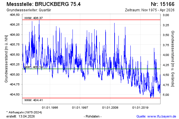
note
Wegen technischen Defekt keine tagesaktuellen Daten.
Groundwater level [m above sealevel]: 404.97
Distance to surface [m]: 4.52
Last value from 23.02.2026 12:00
Ground level [m above sealevel]: 409.49
| Date | Groundwater level [m above sealevel] |
|---|---|
| 23.02.2026 | 404.96 |
| 22.02.2026 | 404.93 |
| 21.02.2026 | 404.79 |
| 20.02.2026 | 404.76 |
| 19.02.2026 | 404.79 |
| 18.02.2026 | 404.80 |
| 17.02.2026 | 404.79 |
| 16.02.2026 | 404.75 |
© Bayerisches Landesamt für Umwelt 2026