
- Start >
- Groundwater >
- Waterlevel of upper layer >
- Iller - Lech - Bodensee >
- Vöhringen, Kässbohrer Süd (BGW 5) >
- Current data

Current data Vöhringen, Kässbohrer Süd (BGW 5)
Groundwater levels of the last 12 months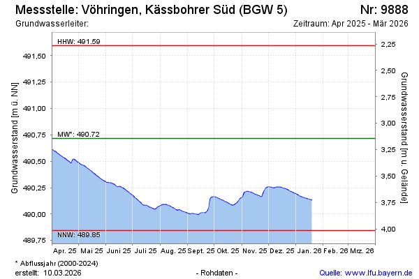
Groundwater level [m above sealevel]: 490.16
Distance to surface [m]: 3.70
Last value from 09.02.2026 11:12
Ground level [m above sealevel]: 493.86
| Date | Groundwater level [m above sealevel] |
|---|---|
| 19.01.2026 | 490.13 |
| 18.01.2026 | 490.13 |
| 17.01.2026 | 490.13 |
| 16.01.2026 | 490.14 |
| 15.01.2026 | 490.14 |
| 14.01.2026 | 490.14 |
| 13.01.2026 | 490.15 |
| 12.01.2026 | 490.15 |
© Bayerisches Landesamt für Umwelt 2026