
- Start >
- Groundwater >
- Waterlevel of upper layer >
- Iller - Lech - Bodensee >
- Vöhringen, Bauschuttdeponie (M3) >
- Current data

Current data Vöhringen, Bauschuttdeponie (M3)
Groundwater levels of the last 12 months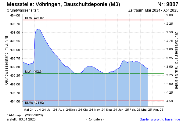
Groundwater level [m above sealevel]: 492.39
Distance to surface [m]: 3.62
Last value from 09.04.2026 09:16
Ground level [m above sealevel]: 496.01
| Date | Groundwater level [m above sealevel] |
|---|---|
| 09.04.2026 | 492.38 |
| 08.04.2026 | 492.39 |
| 07.04.2026 | 492.40 |
| 06.04.2026 | 492.41 |
| 05.04.2026 | 492.41 |
| 04.04.2026 | 492.42 |
| 03.04.2026 | 492.43 |
| 02.04.2026 | 492.44 |
© Bayerisches Landesamt für Umwelt 2026