
- Start >
- Groundwater >
- Waterlevel of upper layer >
- Iller - Lech - Bodensee >
- MITTELSTETTEN MS/12 >
- Chart of total period

Chart of total period MITTELSTETTEN MS/12
Groundwater levels of the total period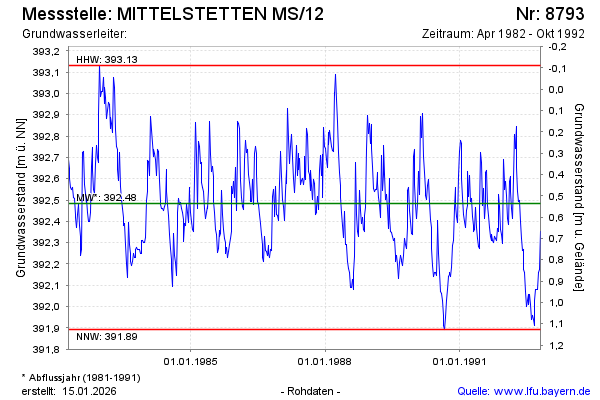
Groundwater level [m above sealevel]: 392.63
Distance to surface [m]: 0.39
Last value from 26.10.1992 12:00
Ground level [m above sealevel]: 393.02
| Date | Groundwater level [m above sealevel] |
|---|---|
| 20.10.1992 | 392.35 |
| 12.10.1992 | 392.17 |
| 05.10.1992 | 392.16 |
| 28.09.1992 | 392.08 |
| 21.09.1992 | 392.08 |
| 14.09.1992 | 392.08 |
| 07.09.1992 | 392.03 |
| 31.08.1992 | 391.91 |
© Bayerisches Landesamt für Umwelt 2026