
- Start >
- Groundwater >
- Waterlevel of upper layer >
- Iller - Lech - Bodensee >
- Illerzell, Friedhof N6 >
- Chart of total period

Chart of total period Illerzell, Friedhof N6
Groundwater levels of the total period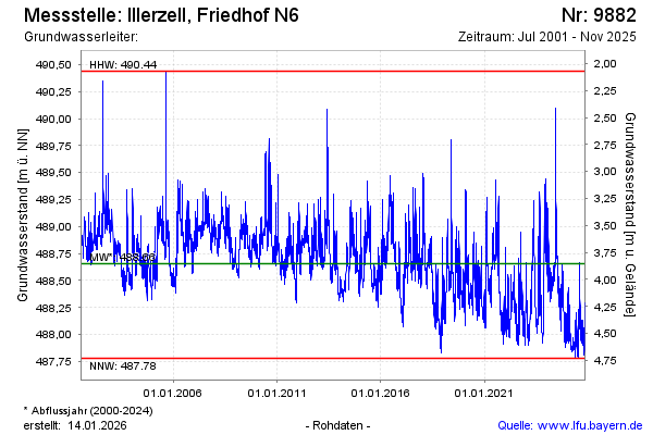
Groundwater level [m above sealevel]: 488.19
Distance to surface [m]: 4.32
Last value from 10.03.2026 14:45
Ground level [m above sealevel]: 492.51
| Date | Groundwater level [m above sealevel] |
|---|---|
| 10.03.2026 | 488.19 |
| 09.03.2026 | 488.20 |
| 08.03.2026 | 488.22 |
| 07.03.2026 | 488.25 |
| 06.03.2026 | 488.28 |
| 05.03.2026 | 488.32 |
| 04.03.2026 | 488.37 |
| 03.03.2026 | 488.43 |
© Bayerisches Landesamt für Umwelt 2026