
- Start >
- Groundwater >
- Waterlevel of upper layer >
- Iller - Lech - Bodensee >
- HWF-DONAUWOERTH P2 >
- Chart of total period

Chart of total period HWF-DONAUWOERTH P2
Groundwater levels of the total period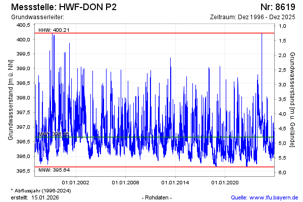
Groundwater level [m above sealevel]: 396.22
Distance to surface [m]: 5.23
Last value from 18.12.2025 10:17
Ground level [m above sealevel]: 401.45
| Date | Groundwater level [m above sealevel] |
|---|---|
| 18.12.2025 | 396.24 |
| 17.12.2025 | 396.26 |
| 16.12.2025 | 396.30 |
| 15.12.2025 | 396.36 |
| 14.12.2025 | 396.41 |
| 13.12.2025 | 396.50 |
| 12.12.2025 | 396.60 |
| 11.12.2025 | 396.72 |
© Bayerisches Landesamt für Umwelt 2026