
- Start >
- Groundwater >
- Waterlevel of upper layer >
- Iller - Lech - Bodensee >
- ERLINGSHOFEN 43 >
- Chart of total period

Chart of total period ERLINGSHOFEN 43
Groundwater levels of the total period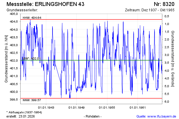
Groundwater level [m above sealevel]: 400.89
Distance to surface [m]: 4.47
Last value from 25.10.1965 12:00
Ground level [m above sealevel]: 405.36
| Date | Groundwater level [m above sealevel] |
|---|---|
| 18.10.1965 | 401.10 |
| 11.10.1965 | 401.27 |
| 04.10.1965 | 401.39 |
| 27.09.1965 | 401.58 |
| 20.09.1965 | 401.74 |
| 13.09.1965 | 401.62 |
| 06.09.1965 | 401.18 |
| 30.08.1965 | 401.32 |
© Bayerisches Landesamt für Umwelt 2024