
- Start >
- Groundwater >
- Waterlevel of upper layer >
- Iller - Lech - Bodensee >
- Bellenberg, Grieshofweg, Unterflur >
- Chart of total period

Chart of total period Bellenberg, Grieshofweg, Unterflur
Groundwater levels of the total period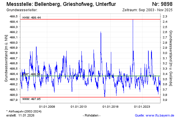
Groundwater level [m above sealevel]: 498.35
Distance to surface [m]: 3.45
Last value from 17.04.2024 10:13
Ground level [m above sealevel]: 501.80
| Date | Groundwater level [m above sealevel] |
|---|---|
| 17.04.2024 | 498.35 |
| 16.04.2024 | 498.34 |
| 15.04.2024 | 498.34 |
| 14.04.2024 | 498.34 |
| 13.04.2024 | 498.34 |
| 12.04.2024 | 498.35 |
| 11.04.2024 | 498.35 |
| 10.04.2024 | 498.36 |
© Bayerisches Landesamt für Umwelt 2024