
- Start >
- Groundwater >
- Waterlevel of upper layer >
- Iller - Lech - Bodensee >
- ALTENSTEIG B7 787 >
- Chart of total period

Chart of total period ALTENSTEIG B7 787
Groundwater levels of the total period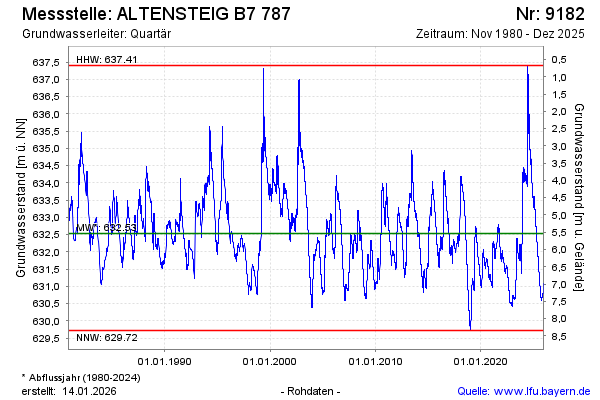
Groundwater level [m above sealevel]: 634.09
Distance to surface [m]: 3.98
Last value from 06.05.2024 00:00
Ground level [m above sealevel]: 638.07
| Date | Groundwater level [m above sealevel] |
|---|---|
| 04.05.2024 | 634.11 |
| 03.05.2024 | 634.12 |
| 02.05.2024 | 634.14 |
| 01.05.2024 | 634.16 |
| 30.04.2024 | 634.17 |
| 29.04.2024 | 634.18 |
| 28.04.2024 | 634.20 |
| 27.04.2024 | 634.21 |
© Bayerisches Landesamt für Umwelt 2024