
- Start >
- Groundwater >
- Waterlevel of upper layer >
- Oberer Main - Elbe >
- WADENDORF 183 >
- Chart of total period

Chart of total period WADENDORF 183
Groundwater levels of the total period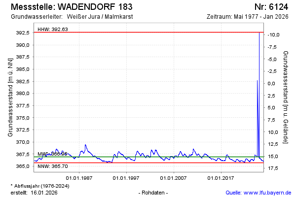
Groundwater level [m above sealevel]: 365.96
Distance to surface [m]: 16.12
Last value from 23.01.2026 10:00
Ground level [m above sealevel]: 382.08
| Date | Groundwater level [m above sealevel] |
|---|---|
| 23.01.2026 | 365.97 |
| 22.01.2026 | 365.96 |
| 21.01.2026 | 365.97 |
| 20.01.2026 | 365.98 |
| 19.01.2026 | 365.96 |
| 18.01.2026 | 365.95 |
| 17.01.2026 | 365.95 |
| 16.01.2026 | 365.96 |
© Bayerisches Landesamt für Umwelt 2026