
- Start >
- Groundwater >
- Waterlevel of upper layer >
- Oberer Main - Elbe >
- MITWITZ(STEINACHTAL) A >
- Chart of total period

Chart of total period MITWITZ(STEINACHTAL) A
Groundwater levels of the total period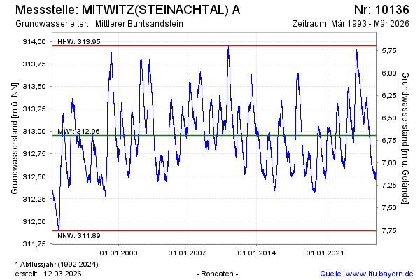
Groundwater level [m above sealevel]: 312.53
Distance to surface [m]: 7.12
Last value from 22.05.2026 05:00
Ground level [m above sealevel]: 319.65
| Date | Groundwater level [m above sealevel] |
|---|---|
| 21.05.2026 | 312.54 |
| 20.05.2026 | 312.55 |
| 19.05.2026 | 312.55 |
| 18.05.2026 | 312.56 |
| 17.05.2026 | 312.57 |
| 16.05.2026 | 312.58 |
| 15.05.2026 | 312.60 |
| 14.05.2026 | 312.61 |
© Bayerisches Landesamt für Umwelt 2026