
- Start >
- Groundwater >
- Waterlevel of upper layer >
- Oberer Main - Elbe >
- LIMMERSDORFER FORST-kms2 >
- Chart of total period

Chart of total period LIMMERSDORFER FORST-kms2
Groundwater levels of the total period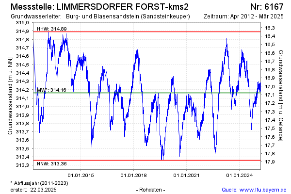
Groundwater level [m above sealevel]: 313.99
Distance to surface [m]: 17.25
Last value from 08.03.2026 09:00
Ground level [m above sealevel]: 331.24
| Date | Groundwater level [m above sealevel] |
|---|---|
| 08.03.2026 | 313.97 |
| 07.03.2026 | 313.98 |
| 06.03.2026 | 313.97 |
| 05.03.2026 | 314.01 |
| 04.03.2026 | 314.01 |
| 03.03.2026 | 314.02 |
| 02.03.2026 | 314.03 |
| 01.03.2026 | 314.02 |
© Bayerisches Landesamt für Umwelt 2026