
- Start >
- Groundwater >
- Waterlevel of upper layer >
- Oberer Main - Elbe >
- KAISERBURG NUERNBERG >
- Chart of total period

Chart of total period KAISERBURG NUERNBERG
Groundwater levels of the total period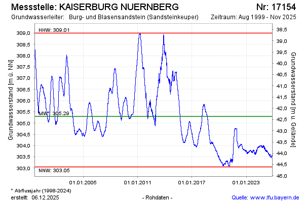
Groundwater level [m above sealevel]: 303.57
Distance to surface [m]: 44.09
Last value from 21.05.2026 10:00
Ground level [m above sealevel]: 347.66
| Date | Groundwater level [m above sealevel] |
|---|---|
| 21.05.2026 | 303.58 |
| 20.05.2026 | 303.58 |
| 19.05.2026 | 303.59 |
| 18.05.2026 | 303.59 |
| 17.05.2026 | 303.60 |
| 16.05.2026 | 303.61 |
| 15.05.2026 | 303.62 |
| 14.05.2026 | 303.60 |
© Bayerisches Landesamt für Umwelt 2026