
- Start >
- Groundwater >
- Waterlevel of upper layer >
- Oberer Main - Elbe >
- GÖSSERSDORF (S 2) >
- Chart of total period

Chart of total period GÖSSERSDORF (S 2)
Groundwater levels of the total period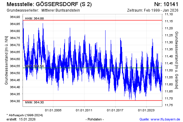
Groundwater level [m above sealevel]: 364.51
Distance to surface [m]: 11.51
Last value from 14.04.2026 06:00
Ground level [m above sealevel]: 376.02
| Date | Groundwater level [m above sealevel] |
|---|---|
| 13.04.2026 | 364.51 |
| 12.04.2026 | 364.50 |
| 11.04.2026 | 364.49 |
| 10.04.2026 | 364.49 |
| 09.04.2026 | 364.46 |
| 08.04.2026 | 364.44 |
| 07.04.2026 | 364.44 |
| 06.04.2026 | 364.44 |
© Bayerisches Landesamt für Umwelt 2026