
- Start >
- Groundwater >
- Waterlevel of upper layer >
- Oberer Main - Elbe >
- BUERGERWALD BT-kms4 >
- Chart of total period

Chart of total period BUERGERWALD BT-kms4
Groundwater levels of the total period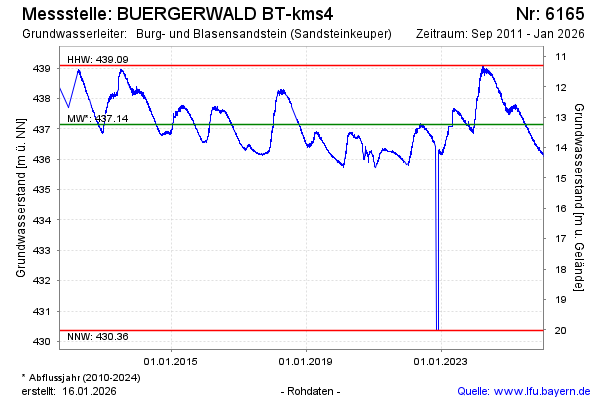
Groundwater level [m above sealevel]: 436.79
Distance to surface [m]: 13.59
Last value from 12.04.2026 10:00
Ground level [m above sealevel]: 450.38
| Date | Groundwater level [m above sealevel] |
|---|---|
| 12.04.2026 | 436.81 |
| 11.04.2026 | 436.80 |
| 10.04.2026 | 436.81 |
| 09.04.2026 | 436.80 |
| 08.04.2026 | 436.77 |
| 07.04.2026 | 436.76 |
| 06.04.2026 | 436.74 |
| 05.04.2026 | 436.78 |
© Bayerisches Landesamt für Umwelt 2026