
- Start >
- Groundwater >
- Waterlevel of upper layer >
- Bayern >
- Wasserlosen Muschelkalk 1 >
- Current data

Current data Wasserlosen Muschelkalk 1
Groundwater levels of the last 12 months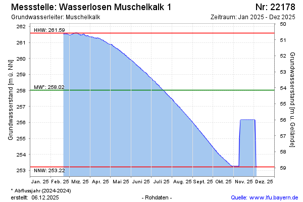
Groundwater level [m above sealevel]: 253.22
Distance to surface [m]: 58.95
Last value from 13.04.2026 09:00
Ground level [m above sealevel]: 312.17
| Date | Groundwater level [m above sealevel] |
|---|---|
| 13.04.2026 | 253.22 |
| 12.04.2026 | 253.22 |
| 11.04.2026 | 253.22 |
| 10.04.2026 | 253.22 |
| 09.04.2026 | 253.22 |
| 08.04.2026 | 253.22 |
| 07.04.2026 | 253.22 |
| 06.04.2026 | 253.22 |
© Bayerisches Landesamt für Umwelt 2026