
- Start >
- Groundwater >
- Waterlevel of upper layer >
- Bayern >
- UNTERZEITLDORN N5 UF >
- Chart of total period

Chart of total period UNTERZEITLDORN N5 UF
Groundwater levels of the total period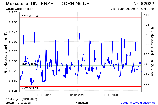
note
GW Messstelle im SN Öberauer Schleife
Groundwater level [m above sealevel]: 315.72
Distance to surface [m]: 2.46
Last value from 02.10.2025 06:00
Ground level [m above sealevel]: 318.18
| Date | Groundwater level [m above sealevel] |
|---|---|
| 02.10.2025 | 315.72 |
| 01.10.2025 | 315.72 |
| 30.09.2025 | 315.73 |
| 29.09.2025 | 315.73 |
| 28.09.2025 | 315.73 |
| 27.09.2025 | 315.74 |
| 26.09.2025 | 315.75 |
| 25.09.2025 | 315.75 |
© Bayerisches Landesamt für Umwelt 2026