
- Start >
- Groundwater >
- Waterlevel of upper layer >
- Bayern >
- UNTERFLOSSING_____359 >
- Chart of total period

Chart of total period UNTERFLOSSING_____359
Groundwater levels of the total period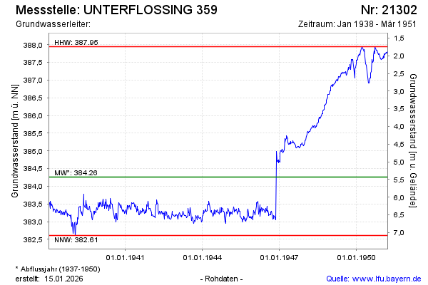
note
Die Messstelle wird nicht mehr beobachtet
Groundwater level [m above sealevel]: 387.81
Distance to surface [m]: 1.88
Last value from 27.03.1951 12:00
Ground level [m above sealevel]: 389.69
| Date | Groundwater level [m above sealevel] |
|---|---|
| 19.03.1951 | 387.80 |
| 12.03.1951 | 387.77 |
| 05.03.1951 | 387.78 |
| 26.02.1951 | 387.77 |
| 19.02.1951 | 387.76 |
| 12.02.1951 | 387.73 |
| 05.02.1951 | 387.74 |
| 30.01.1951 | 387.65 |
© Bayerisches Landesamt für Umwelt 2026