
- Start >
- Groundwater >
- Waterlevel of upper layer >
- Bayern >
- Stadtwald / Würzburg (WÜ- MU 4) >
- Chart of total period

Chart of total period Stadtwald / Würzburg (WÜ- MU 4)
Groundwater levels of the total period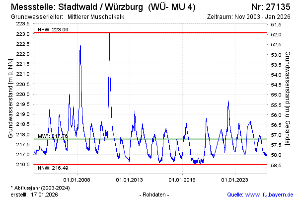
note
Messgerät seit 22.10.23 defekt; nur monatliche Einzelwerte
Groundwater level [m above sealevel]: 218.39
Distance to surface [m]: 56.57
Last value from 12.03.2024 09:35
Ground level [m above sealevel]: 274.96
| Date | Groundwater level [m above sealevel] |
|---|---|
| 11.03.2024 | 193.77 |
| 10.03.2024 | 188.46 |
| 09.03.2024 | 188.43 |
| 08.03.2024 | 188.37 |
| 07.03.2024 | 188.28 |
| 06.03.2024 | 188.24 |
| 05.03.2024 | 188.25 |
| 04.03.2024 | 188.25 |
© Bayerisches Landesamt für Umwelt 2024