
- Start >
- Groundwater >
- Waterlevel of upper layer >
- Bayern >
- SCHWABHOF/AUGSBURG 67 >
- Chart of total period

Chart of total period SCHWABHOF/AUGSBURG 67
Groundwater levels of the total period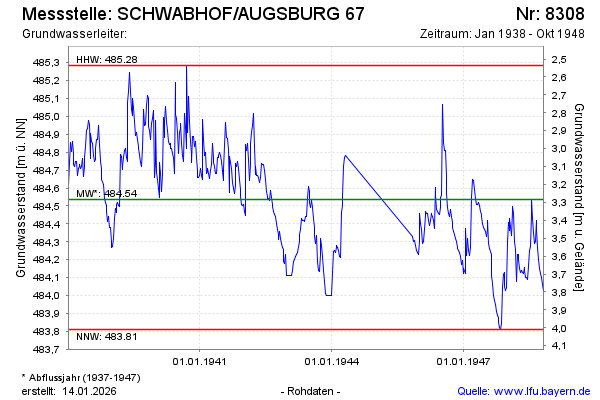
Groundwater level [m above sealevel]: 484.00
Distance to surface [m]: 3.82
Last value from 30.10.1948 12:00
Ground level [m above sealevel]: 487.82
| Date | Groundwater level [m above sealevel] |
|---|---|
| 23.10.1948 | 484.03 |
| 16.10.1948 | 484.06 |
| 09.10.1948 | 484.10 |
| 02.10.1948 | 484.12 |
| 25.09.1948 | 484.15 |
| 18.09.1948 | 484.20 |
| 10.09.1948 | 484.27 |
| 02.09.1948 | 484.37 |
© Bayerisches Landesamt für Umwelt 2026