
- Start >
- Groundwater >
- Waterlevel of upper layer >
- Bayern >
- SCHROBENHAUSEN D 17 >
- Chart of total period

Chart of total period SCHROBENHAUSEN D 17
Groundwater levels of the total period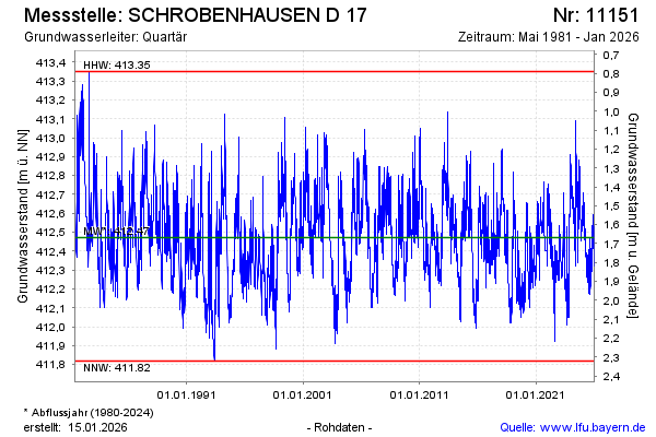
Groundwater level [m above sealevel]: 412.60
Distance to surface [m]: 1.54
Last value from 18.03.2026 09:00
Ground level [m above sealevel]: 414.14
| Date | Groundwater level [m above sealevel] |
|---|---|
| 18.03.2026 | 412.60 |
| 17.03.2026 | 412.60 |
| 16.03.2026 | 412.58 |
| 15.03.2026 | 412.59 |
| 14.03.2026 | 412.62 |
| 13.03.2026 | 412.63 |
| 12.03.2026 | 412.62 |
| 11.03.2026 | 412.63 |
© Bayerisches Landesamt für Umwelt 2026