
- Start >
- Groundwater >
- Waterlevel of upper layer >
- Bayern >
- REISCHACH 805 >
- Chart of total period

Chart of total period REISCHACH 805
Groundwater levels of the total period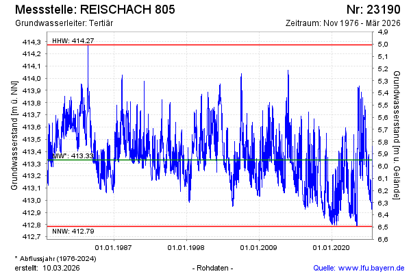
Groundwater level [m above sealevel]: 413.08
Distance to surface [m]: 6.20
Last value from 09.03.2026 11:12
Ground level [m above sealevel]: 419.28
| Date | Groundwater level [m above sealevel] |
|---|---|
| 09.03.2026 | 413.08 |
| 08.03.2026 | 413.08 |
| 07.03.2026 | 413.09 |
| 06.03.2026 | 413.11 |
| 05.03.2026 | 413.12 |
| 04.03.2026 | 413.14 |
| 03.03.2026 | 413.16 |
| 02.03.2026 | 413.20 |
© Bayerisches Landesamt für Umwelt 2026