
- Start >
- Groundwater >
- Waterlevel of upper layer >
- Bayern >
- Pfaffenhausen 82A >
- Chart of total period

Chart of total period Pfaffenhausen 82A
Groundwater levels of the total period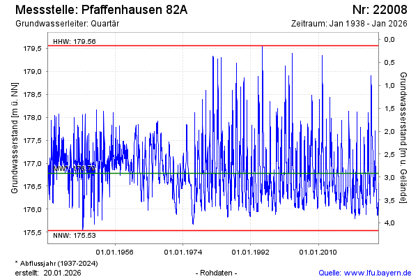
Groundwater level [m above sealevel]: 177.51
Distance to surface [m]: 2.19
Last value from 09.03.2026 10:00
Ground level [m above sealevel]: 179.70
| Date | Groundwater level [m above sealevel] |
|---|---|
| 09.03.2026 | 177.53 |
| 08.03.2026 | 177.56 |
| 07.03.2026 | 177.59 |
| 06.03.2026 | 177.63 |
| 05.03.2026 | 177.66 |
| 04.03.2026 | 177.68 |
| 03.03.2026 | 177.70 |
| 02.03.2026 | 177.72 |
© Bayerisches Landesamt für Umwelt 2026