
- Start >
- Groundwater >
- Waterlevel of upper layer >
- Bayern >
- OBERWOEHR-MANGF.AU 21A >
- Current data

Current data OBERWOEHR-MANGF.AU 21A
Groundwater levels of the last 12 months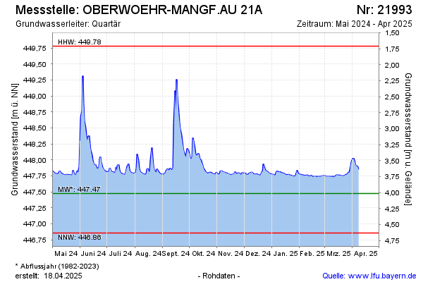
note
Die Messstelle musste 2009 verlegt werden !
Groundwater level [m above sealevel]: 447.84
Distance to surface [m]: 3.65
Last value from 07.04.2026 12:07
Ground level [m above sealevel]: 451.49
| Date | Groundwater level [m above sealevel] |
|---|---|
| 07.04.2026 | 447.83 |
| 06.04.2026 | 447.80 |
| 05.04.2026 | 447.77 |
| 04.04.2026 | 447.77 |
| 03.04.2026 | 447.77 |
| 02.04.2026 | 447.76 |
| 01.04.2026 | 447.76 |
| 31.03.2026 | 447.77 |
© Bayerisches Landesamt für Umwelt 2026