
- Start >
- Groundwater >
- Waterlevel of upper layer >
- Bayern >
- Niederschönenfeld 109B >
- Current data

Current data Niederschönenfeld 109B
Groundwater levels of the last 12 months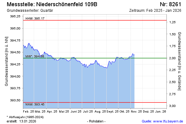
note
Derzeit keine aktuellen Daten zur Verfügung!
Groundwater level [m above sealevel]: 394.64
Distance to surface [m]: 1.74
Last value from 12.02.2026 08:38
Ground level [m above sealevel]: 396.38
| Date | Groundwater level [m above sealevel] |
|---|---|
| 12.02.2026 | 394.62 |
| 11.02.2026 | 394.60 |
| 10.02.2026 | 394.54 |
| 09.02.2026 | 394.48 |
| 08.02.2026 | 394.46 |
| 07.02.2026 | 394.45 |
| 06.02.2026 | 394.48 |
| 05.02.2026 | 394.50 |
© Bayerisches Landesamt für Umwelt 2026