
- Start >
- Groundwater >
- Waterlevel of upper layer >
- Bayern >
- Neu-Ulm, Ludwigsfeld westl. der BAB >
- Current data

Current data Neu-Ulm, Ludwigsfeld westl. der BAB
Groundwater levels of the last 12 months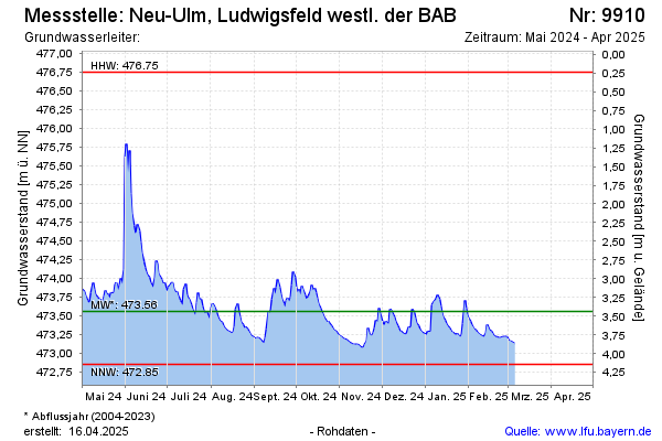
Groundwater level [m above sealevel]: 473.66
Distance to surface [m]: 3.33
Last value from 09.12.2025 13:35
Ground level [m above sealevel]: 476.99
| Date | Groundwater level [m above sealevel] |
|---|---|
| 09.12.2025 | 473.65 |
| 08.12.2025 | 473.39 |
| 07.12.2025 | 473.24 |
| 06.12.2025 | 473.25 |
| 05.12.2025 | 473.26 |
| 04.12.2025 | 473.29 |
| 03.12.2025 | 473.33 |
| 02.12.2025 | 473.37 |
© Bayerisches Landesamt für Umwelt 2026