
- Start >
- Groundwater >
- Waterlevel of upper layer >
- Bayern >
- MRKT SCHWABEN 79/232 >
- Chart of total period

Chart of total period MRKT SCHWABEN 79/232
Groundwater levels of the total period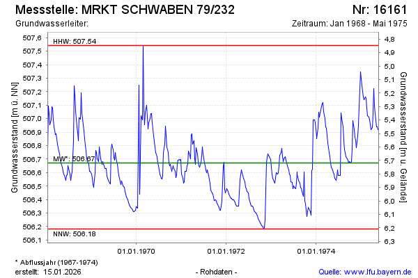
note
Die Messstelle wurde 1975 zurück gebaut.
Groundwater level [m above sealevel]: 506.92
Distance to surface [m]: 5.47
Last value from 27.05.1975 12:00
Ground level [m above sealevel]: 512.39
| Date | Groundwater level [m above sealevel] |
|---|---|
| 20.05.1975 | 506.92 |
| 13.05.1975 | 506.94 |
| 06.05.1975 | 506.94 |
| 29.04.1975 | 507.04 |
| 22.04.1975 | 507.09 |
| 15.04.1975 | 507.22 |
| 08.04.1975 | 507.03 |
| 01.04.1975 | 506.93 |
© Bayerisches Landesamt für Umwelt 2026