
- Start >
- Groundwater >
- Waterlevel of upper layer >
- Bayern >
- MOOS NR 22 366 >
- Chart of total period

Chart of total period MOOS NR 22 366
Groundwater levels of the total period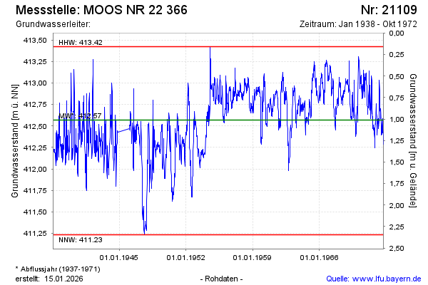
note
Die Messstelle wurde 1972 zurück gebaut
Groundwater level [m above sealevel]: 412.31
Distance to surface [m]: 1.27
Last value from 09.10.1972 12:00
Ground level [m above sealevel]: 413.58
| Date | Groundwater level [m above sealevel] |
|---|---|
| 02.10.1972 | 412.31 |
| 25.09.1972 | 412.28 |
| 18.09.1972 | 412.41 |
| 11.09.1972 | 412.47 |
| 04.09.1972 | 412.42 |
| 28.08.1972 | 412.50 |
| 21.08.1972 | 412.59 |
| 14.08.1972 | 412.48 |
© Bayerisches Landesamt für Umwelt 2026