
- Start >
- Groundwater >
- Waterlevel of upper layer >
- Bayern >
- Mertseebecken 5 >
- Chart of total period

Chart of total period Mertseebecken 5
Groundwater levels of the total period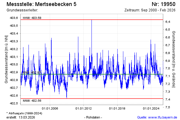
note
GW Messstelle im SN HRB Mertsee EG
Groundwater level [m above sealevel]: 402.94
Distance to surface [m]: 7.01
Last value from 31.03.2026 00:00
Ground level [m above sealevel]: 409.95
| Date | Groundwater level [m above sealevel] |
|---|---|
| 30.03.2026 | 402.84 |
| 29.03.2026 | 402.81 |
| 28.03.2026 | 402.83 |
| 27.03.2026 | 402.82 |
| 26.03.2026 | 402.85 |
| 25.03.2026 | 402.89 |
| 24.03.2026 | 402.84 |
| 23.03.2026 | 402.85 |
© Bayerisches Landesamt für Umwelt 2026